Between 9 and 12 November, 1999,
I traveled to Wisconsin, taking Mike Willett our Senior Technical
Assistant, to accomplish three things.
First to become familiar with the
Researchers, staff, facilities, and research activities at the Center
for Limnology, University of Wisconsin - Madison, which supports
the North Temperate Lakes LTER at its two locations - Lake Mendota
Lab and Trout Lake Station. (http://limnosun.limnology.wisc.edu/)
Secondly to make the first inquiry
into what research we might be able to support, wirelessly, at Mendota
Lake.
Thirdly, we needed to do the Site
survey of the principle lakes being studied from the Trout Lake
Station, 200 miles north of Madison, and determine the first work
to be done installing radios to connect their data logger instruments
back to the servers and thence to the Internet at the Station.
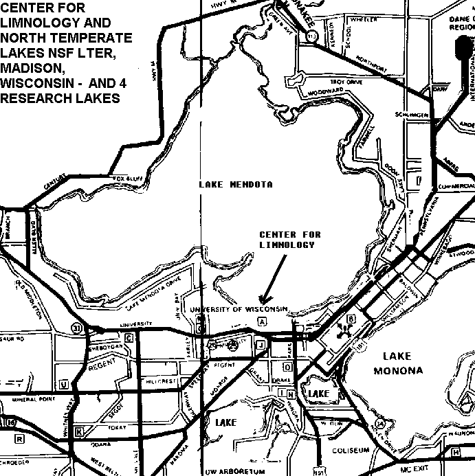
Center for Limnology
We got a good tour of the Center
by Dave Harring - its labs, boats, and ability to fabricate tools
necessary to support the research on several close-by lakes, the
main one being Mendota Lake that is quite large, fronting Madison,
Wisconsin, the University, and on which the Center sits, with the
boat dock inside the Center. So this site is right on the water
itself.
The attached map shows part of
Madison, the location of the University and Center for Limnology
with respect to Mendota Lake: click
here for Mendota Lake LTER Map
We first met with Paul Hanson, graduate
student and chief Center administrator for for the Limnology Center,
and several of his associates and assistants.
A major project that Paul Hanson
is heading up, which was enabled by the most recent NSF grant, involves
adapting a large ($100,000) floating platform - a buoy - with solar
panels providing power to devices on the float, one major one of
which will be a Carbon Dioxide measuring system that has to deal
with a column of water below. Stimulated by discussions and a conference
call I had on my first visit to Wisconsin last March, already (early
November), Hanson has purchased and tested a pair of Aironet Spread
Spectrum radios. In fact, he notes, that when he put up the base
radio at he Center, and crossed the lake with the other radio, the
link worked flawlessly all the way, 5 miles, across the lake. The
only time it did not was when their boat went behind something that
would block line of sight back to the Center and its radio. This,
of course, is to be expected, for the Aironet radio family operates
at 2.4 to 2.483 Ghz of frequency, with only 100 milliwatts of power.
So, together with a graduate student
who is a computer science major, Hanson hopes to use the radio link
to connect up the devices on the buoy back to the center, to afford
real-time data collection. They will attempt to interface an Aironet
PCMCIA card (PCMCIA 4800 model) to a special device, rather than
mount a complete laptop on the raft. This will conserve power. But
it will require a pretty technical fabrication of such an interface.
Thus, already, the Center is plunging
into wireless, and other than offer them advice, we do not need
to be much involved with this project unless they need our expertise.
An Interesting Challenge
We met the new Director of the
LTER, Steve Carpenter, who is taking over those responsibilities
from John Magnuson, who will be retiring. Dr. Carpenter described
a problem which grabbed my attention, for I thought there could
be a way to solve it with a novel use of wireless.
The LTER project has some sort
of arrangement that provides for satellite mapping photography to
be produced every two weeks - as the satellite passes overhead and
looks down on Madison and the four close-in lakes. The photographic
maps are, of course, color coded to represent a range of conditions
- such as temperature - at the moment the satellite passes over.
A problem is, however, how to 'calibrate'
the satellite imagery so that its colors and overlays perfectly
match the corresponding condition on the lakes. The way this is
done now is very labor intensive, according to Dr. E Carpenter.
When they desire to get accurate, calibrated maps from the passover,
they deploy up to 60 people in up to 15 teams in boats to reach
all portions of the lakes over just a few total hours time, to fetch
samples from the water, which are then taken back to the lab to
be analyzed, and then the results of all the 'points' fed into the
mapped imagery data, in order to 'calibrate' the image code to the
actual conditions at that time. Thus producing maps, in which the
concentration of chlorophyll, for example, is represented accurately
on the map, from the sampling at many points taken over a very short
period of time.
It immediately occurred to me that
it should be possible, and economically enough to consider, to deploy
the same number of chlorophyll (or multiple-function) sensors that
are lightly anchored to the bottom of the somewhat shallow lakes,
that are equipped with very small, minimum-data communicating, devices,
perhaps even interfaced, battery powered pager-like devices, which
can send data on command to pager satellites which cover most of
the US. The amount of data may be, as frequently is the case for
current data loggers used by biological scientists, very small -
just bursts of number sequences. Thus pager technology might be
able to handle the rate.
Then, having deployed the floats,
pager-data devices, sensors, anchors and connecting lines, at the
time the imagerying satellite passed over the pager-data devices
could be commanded to communicate their readings at one point in
time. Thus permitting calibration of the images.
The floats could be put out by
one or two boat crews in the days proceeding the Passover schedule
of the imagery satellites.
The questions, of course, would
be, are there economical enough sensors to permit deployments of
large enough numbers. Paging devices certainly are.
What would it take to interface
the sensors to the pagers, and protect them in the water.
An alternative, if multiple 'chlorophyll'
sensors, for example, are too costly, the linking of the pagers
to an 'open and close on command' water sample containers might
work. Where the satellite delivered command would tell the sensors
to open the container, then close it, and await manual retrieval.
Much to think about.
LTER Science Meeting
One of the reasons we visited Madison,
was to attend a meeting of LTER researchers gathering to discuss
some longer term research strategies. In particular about a set
of NSF initiatives that can be called the 'Era of Scientific Observatories.'
We also were asked to make a brief presentation ourselves to acquaint
the researchers and Limnology Center staff with this NSF 'Biology
by Wireless' project and why were there in Wisconsin.
The hour and a half meeting covered
several subjects. First was a presentation by Dr. Frost, recently
assigned to the NSF in Washington, on the concept of Science Observatories
- by which is meant not a singular astronomy-like observatory, but
a complex of observation sites, which may be substantially funded
by the NSF, with specific, one-observatory-a-budget-year, approval
by Congress.
Then Dr. Triplett explained his
Microbial Observatory plan, with a focus on biological organisms.
The buoy Project was laid out by Paul Hanson.
I presented the details on this
Wireless Project, and how it came to be, and what we expected to
accomplish.
Dr. Tim Kratz, of the Trout Lake
site then took the floor and explained activities going on at the
Trout Lake site called NEON. This melded into the general discussion
about large science issues and questions which will have to be crystallized
before thinking about applying for a competitive Observatory grant.
The topics also covered the places that might be included in such
a set of studies, the kinds of instruments needed, and the intellectual
centers and people the LTER would want to partner with.
Then Mike Willett and I left for
the 4 hour drive (faster than making air connections) to Trout Lake,
northwest of Rhinlander, Wisconsin, and the middle of the lake region
of Northern Wisconsin.
That part of the trip is discussed
in the next Progress Report.

