PROGRESS REPORT #5
November 17, 1999
Site Surveys at Trout Lake
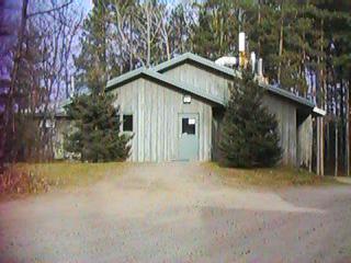
We put up, sleeping bags and all, in one of
the Cabins at the Trout Lake LTER Station (Northern Temperate
Lakes LTER) the night of November 10th and 11th.
Thursday, November 10th, we met with
Tim Kratz, the senior PI (Principal Investigator) of the Station,
and Tim Meinke, Technical assistant at Trout Lake - both of whom
have been at Trout Lake for 20 years. (there is a research, technical,
and administrative staff of about 10 at Trout Lake. Tim Meinke handles
most of the lake equipment, including the raft on Sparkling Lake
- the only lake that has a set of sensors, data loggers, and communicating
cell phone system on it. This year they will attempt to leave the
raft in the water all winter long, which they have not done before.
Obviously the ice and snow that starts in November, and continues
through spring, poses many problems for maintaining reliable data
collection all winter long.
By agreement with Tim Kratz, our first
priority is to connect up the Sparkling Lake data collection system
to the Trout Lake facility, wirelessly.
As soon as that is done, with planning
and design work starting now, the second priority is to construct
a wireless network which can reach and connect up the 7 primary
lakes where scientific work is being done from the Station. Onto
which there will progressively be placed further sensors, data loggers,
and floating rafts, with their own power supplies - in order to
gather, record, and communicate data all year round. Five of the
lakes are called lakes, while two quite small lakes - ponds - are
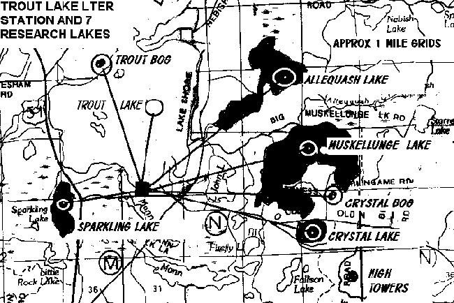
called bogs. The map below show the lakes.
As the map shows, the 7 target
lakes, Trout, Muskellunge, Allequash, Crystal, Sparkling, and the
two bogs - Crystal Bog and Trout Bog, are all within 5 miles of
the Trout Lake Station itself.
Sparkling Lake is only approximately
1.3 miles from the main building at the Station - where the T-1
line from the University of Wisconsin terminates in a router, an
NT server, and a local area network.
The challenge for connecting up the 7 lakes
wirelessly, however, is that the ground is relatively flat throughout
the area, with the slight exception of 'Muskie Mountain' a few
hundred feet higher than the surrounding countryside. And the
entire area is covered with sparse to dense trees, both deciduous
and evergreen. They average 60' in height. Thus if we use no-license
spread spectrum radios, which operate in the 902-928 Mhz and 2.4
to 2.483 Ghz frequency bands, at power levels from 100 milliwatts
to 1 watt (at the radios) we cannot put the radios at ground -
or lake surface level and expect them to reach the Station, even
if there is a tower on the main building. By inspection, from
our experience, there will be too much attenuation.
So at first glance it appears we must look
for ways to gain height by towers, get the maximum antenna gain,
and highest FCC permissible power, and, where necessary, use relay
station radios.
And in all lake-site cases, we have to provide
for rechargeable power. To drive both the radios and data logger
and sensor instruments.
We agreed that we would concentrate on the
Sparkling Lake case first, and get all the information we needed
to order duplicate data loggers on which to design interfaces
here in Colorado between trips to Trout Lake where we expect to
visit largely to install radios and interfaces, both hardware
and software.
SPARKLING LAKE
Out in the middle of Sparkling Lake is a raft
built at the station which is approximately 6 feet by 6 feet,
under whose timbers are watertight cans that gives it good flotation
with about 12" of freeboard. The raft will easily support
a man, even two, although working on it while on the water would
be awkward and slow. The Station prefers to pull it out of the
water and take it back to the work sheds for modification.
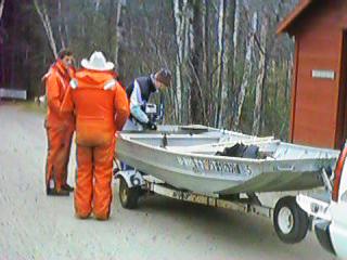
Myself, Mike Willett and Tim Kratz took a power
boat out to the raft launched and navigated by Tim Meinke. There
was a brisk breeze blowing. No ice had formed yet (10 November)
but it was clear it would be forming soon. We wore water survival
suits.
Boat
and Boaters
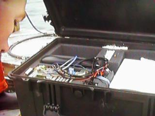
On the raft is a locked case containing a
Campbell Data Logger and a special interface, to which is connected
numerous censors, a battery case, a spare smaller case, and
the solar panel tilted at a 45 degree angle to the south.
Raft
and Gear
The sensors consisted of 3 Anemometers operating
at 1, 2, and 3 meters of height above the raft. They are affixed
to a metal pole which looks to be about 3/4 of an inch in diameter.
Then there are Relative Humidity and Air Temperature instruments
above water, and 10 Thermisters hanging below the raft to a
depth of 16 feet. These are the sensors which send their data
to the data logger, storing it, and awaiting calls over a cell
telephone which is rigged to turn on and draw power only when
a call comes in.
Open
Case with Data Logger
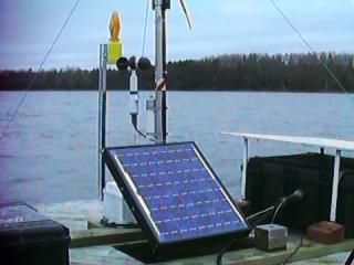
Then there is a solar panel about 2 by 3
feet that recharges the 12 volt battery that powers everything.
Solar
Panel on Raft
Until this year, the raft was pulled from
the lake before the ice came in, and put back into the water
in the spring. The ice starts forming in November, and the staff
cannot go out onto the ice until late December. Because our
NSF project was approved and funded two months later than we
requested, this makes it touch and go to see if we can get a
wireless link installed before the ice makes it impossible for
about two months. After which we can get out on the ice with
equipment, but the raft will be frozen in, and cannot be extensively
modified.
We discussed various ways to solve the most
critical problem at the raft, which will be the reliable generation
of sufficient power to keep the battery or batteries powering
all equipment, plus the radios which must operate continuously.
(perhaps)
Our consensus was that it will take a wind
generator besides a solar panel, to keep it all functioning
even when snow covers the solar panel, and weak winter short
day sun cuts down on the solar panel input. But since the anemometers
are very sensitive to disturbance, it was also a consensus that
we ought to plan on putting a second raft into the water to
carry all the wireless equipment - sealed radio boxes, mounted
antenna, possibly a 13dB gain directional panel, battery, solar
panels, pole and wind generator. Which should kick in to produce
effective power at about 6 knots of wind speed. Tim Kratz was
going to look up the data on past readings, but felt that on
the larger lakes at least, wind would be present much of the
time.
The second challenge for the Sparkling Lake
site is getting the wireless signal from the lake level to the
Station, through or around the dense trees which occupy at least
74% of the ground between. Until we test both 915Mhz radios
at 1 watt of power and perhaps a 24db antenna at both ends,
with a 60 foot roof tower at the Station, we cannot know to
what extent the trees can be penetrated. If they cannot be,
we may be able to mount a relay radio, high on a tree halfway
between, to get the signal through.
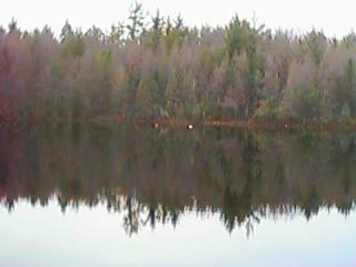
Typical
Shore Line Trees
Only a later trip with spectrum analyzer
and radios we can temporarily install will give us the answers.
Even then, the snow build up on trees will inject another unknown-value
problem.
Then the main challenge, will be redesigning
the interface between the data logger and the wireless, then
integrating it into the station computer system as well as the
Madison data storage site. For as it turns out, BOTH the Trout
Lake site AND the Limnology Center site 'poll' the data logger
via telephone modem. The Limnology data center has its system
rigged to automatically, every two weeks, 'call' via long distance
and modem to the cell phone on the raft. A switch detects the
call attempt, power is applied to the cell phone, it answers,
and stored data flows to Madison Wisconsin where it is added
to the data stored there.
Then, whenever the Trout Lake site wants
to know the same data, or to check that the system is operating
correctly, Tim Meinke can manually order his computer and modem
to place the call, and link the data to the Campbell Scientific
Software designed to present and save the data from their loggers.
The problem this presents is whether or not
the researchers are going to expect that BOTH the wireless and
the cell phone system will operate for a time while the bugs
of the wireless are worked out. If so, since the data comes
out of the Campbell loggers RS232 port, we may face a tricky
'split' RS232 feed. Many software questions need to be answered
here before we can proceed. Some of whose answers are at the
Limnology Center, not at Trout Lake.
We concluded our analyses of the Sparkling
Lake site by identifying the problems we have to solve.
MUSKI MOUNTAIN TOWERS
We then visited all 6 of the other lake sites,
starting with a revisit (for me) to the towers on Muski Mountain,
about 4 miles south east of the Trout Lake station.
There is a Wisconsin Electric Power large
tower, with multiple radios - most looking like cell phone antennas
- on it, up to its ringed 200 or so foot top. There is another
very tall tower (450') about a 1/4 mile from the Wisconsin Power
tower, and lower down. It appears that this tower, with television
relay and cell phone antennas extends at least 100 feet higher.
Both towers look very attractive for the
placement by us of a relay radio sight that can at once serve
the Trout Lake Station with one 4 mile leg, and then reach out
to as many lakes of the 7 as are reachable through no trees,
or only an edge of them.
We will now contact the tower owners to see
under what conditions and at what price we can mount equipment
on either of the two towers.
While we were there a crew with many vehicles
was working on the tallest tower. This one requires a winch
truck with a very long cable anchored at the top, to haul a
worker up the tower on a seat. So we will have to contract with
someone to do that work.
Climbing up on a lower fire lookout station
tower by Tim Kratz to about 100 feet determined that several
lakes were visible from it.
As we visited the other 6 lakes, the towers
were visible from three of them, and the Trout Lake itself is
visible across the water directly to the Station, which is near
the water and on a hill of perhaps 50 feet above the water's
edge.
So the idea of putting the base radio at
the Station, on a 60 foot tower, which then with directional
antenna shoots to a radio at the top of one of the high towers
on Muski Mountain, and then down to as many lakes as can be
'seen' by lake-level radios, looks like one we will have to
follow.
Given the data rates coming out of the Campbell
Loggers - which appear to be less than 9,600 baud, we may try
the reliable, amd full 1 watt FreeWave DRG115 radios at first.
THE 7 LAKES
We drove to the edge of all 5 lakes and two
smaller 'ponds' called Bogs, and saw the same essential problem
everywhere - 60 foot high trees ringing the lakes close in.
With a challenge getting the signal from water level on the
lakes high enough to link to the towers, and thence to the Station.
The bogs also might pose the problem of insufficient wind to
make wind generators useful. But given the distance to all is
less than 5 miles, it looks like we can get the job done by
next summer. While we will try to get Sparkling Lake connected
wirelessly by early spring.
Across
Trout Lake
Crystal
Lake
Trout
Bog
Previous
Next

|
