We left for Puerto Rico on Sunday,
November 21st, 1999. We settled at
a humble hotel near the foot of El Yunque. Resources we take for
granted on the mainland, are sparse
in PR, such as basic communications.
We had no phone in our rooms, and were
therefore unable to tie into the Internet for email and other
access needs that seem so easy in the US mainland.
Luquillo LTER Sites
Monday, we met with Doug Schaefer,
an LTER researcher at the University of
Puerto Rico in San Piedras. We talked about present operations and
future plans. We talked about our ideas
about how wireless could best facilitate
their requirements, and to determine exactly what equipment was
being used. It was a very productive brain storming session. It
is fairly clear now that the two LTER sites, Wisconsin and Puerto
Rico, have effectively standardized
on the Campbell Scientific Data Loggers. This
will make the effort to provide interfaces between the wireless
and the data logger equipment easier,
since both sites will have the same basic
data needs.
Doug Schaefer provided ideas and
descriptions about some aspects their present
operation. For the first phase, our primary interest will be three
meteorological stations. One each of
three stations are located at Bisley, Pico
del Este, and at El Verde. If not already so, each station will
be equipped with the Campbell Scientific
Data Logger, model CR10X.
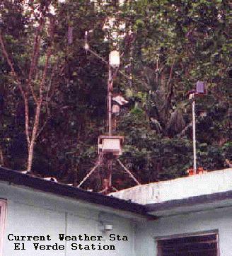
The weather
station at El Verde is on the roof of the El Verde station,
itself, and is not an effective tool in that spot. Shaded by the
trees from sun, precipitation and wind, the station can not provide
the data desired. Doug is moving the weather station to the top
of the 70ft tall experimentation and observation tower located just
south and up the hill from the research center.
The parameters of meteorological
data acquired includes Min/Max Temperatures,
Relative Humidity, Precipitation, Wind Direction and Speed.
We had a general discussion about
the LAN to be installed at El Verde, the Web
site administration, and talked about other parties involved with
the meteorological stations and their
rolls.
The National Forest Service Research
Stations
BISLEY:
One individual is Fred Scatena with
the National Forest Service at Sabana.
Fred works with all three sites. His primary point of interest
is the experimentation tower at Bisley, where they track the normal
parameters of weather, but also includes measurements of light.
The parameters of light include
light arriving at the forest canopy as well
as the light reflected back from the forest canopy. It also includes
the measurements of the wavelengths
of light most active in the roll of photosynthesis
as well as other light spectrums, providing a direct correlation
between forest productivity and effective hours of light the forest
receives.
The Bisley location actually has
three recording stations. One at the water
shed, measuring stream flow, water level, and also pH, dissolved
oxygen and conductivity. The second
at the base of the tower at Bisley, and
a third at the top of the tower at Bisley.
The water shed site was run by the
National Forest Service years ago with a
satellite uplink. Although the satellite uplink is no longer active,
the gear remains, in this case the
data logger is a Sutron 8210 unit.
This station is monitored via a
physical visit to the site, and the data is
downloaded to a PCMCIA memory card. The PCMCIA data is then downloaded
to a PC at the research center.
Two weather monitoring sites reside
up hill from the water shed location. At
the end of a trail running approximately 1/4 to 1/2 mile from the
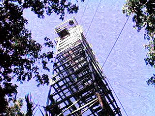
forest access road, exists a tower
similar to the one at the El Verde station.
This tower, however, extends to a height of approximately 110 to
120 feet. At the top there is weather
measurement equipment, such as at El Verde,
but in addition includes light measurement equipment, such as the
quantum light sensor, which measures
a wide range of light spectrum, including
IR, as well as the PARE light sensor, which is primarily sensitive
to the light spectrum most effective in the photosynthesis process
of plants.
The other weather station, near
the base of the tower is used primarily for
parts, but also offers a comparative measurement of the environment
above the forest canopy vs the environment
below the canopy.
Since hurricanes have hit the island
a few times in the past several years,
Fred was able to point out some distinct features that could be
attributed to the effects of the storm.
One is that the foliage on the forest
floor is greater after the hurricanes wipe out the foliage of the
forest canopy, which allows greater
amounts of light to hit the forest floor.
Another is the trees at the top of the ridge survive the storms
better than those nestled within the
confines of the valleys. He proposed that
the root system was better at the ridge tops and trees, which easily
loose their leaves in a strong wind
could shed the wind loading that would topple
a typical valley grown tree. These concepts, with the ability to
monitor and test predictions in real
time will greatly enhance the understanding
of the major impacts on the forest, such as those great changes
caused by hurricanes.
The Bisley site offers several challenges.
One, the site has no power other than
naturally generated, such as by solar. Two, the line of site to
other locations can be considered marginal,
as the site can see no location other
than part of the tower sites at El Yunque. Three, the tower site
is already fairly populated with sensors, and the addition of a
solar panel may interfere with present
light measurements. Four, since radios consume
more power than the measurement instruments, the solar panel would
have to be fairly large, which increases
the wind loading during storms. It
is clear that the radio interface challenge of the project, along
with acquiring line of site to the
research centers has been met with the larger
challenge of powering the radios and interface equipment of the
remote locations.
Pico Del Este:
Rain measurements in the continental
US are typically presented in inches. The
rain fall at Pico Del Este is presented in meters. Approximately
5 meters, or 16 feet of rain fall at
Pico Del Este per year. A unique result of
measurement here concluded more water was being produced by the
mountain top rain forest than what
was being measured in rainfall. This observation,
which one could easily attribute to experimental flaw, is now being
tested for the concept of "Cloud Drip". Not related to true rainfall,
which is condensation resulting in precipitation due to changes
in temperature or pressure, the idea
regarding cloud drip is condensation due
to physical contact between the water vapor of the cloud and a solid
object. The top of the rain forest
is located within the clouds much of the
year. The cloud, or water vapor, comes into contact with the forest
itself, such as the shrubs, leaves,
tree trunks, etc. The water vapor of the
cloud condenses on the solid object, resulting in a drop of water.
This in turn, reaches the point in
size where the drop falls to the ground and
together with other such drops of water, becomes a significant portion
of the water shed of the rain forest
at the highest elevations.
So, simply put, the weather stations
of Pico Del Este consist of several monitoring
stations. It also includes a unique sensor system, which is a rain
fall gauge, covered from rain, but able to trap moisture from the
water vapor of the cloud. This allows
it to condense on a screen (the solid
object) and be measured in the same capacity as rainfall.
Providing networking to the Sabanna
station will be a challenge. It sits in
a very low part of the valley, surrounded by trees. We have more
work to do regarding this site.
THE PARROT PROJECT:
One of the more colorful projects
we may undertake is the monitoring of the
rare Puerto Rican Parrot. A low in the population put the bird at
extremely endangered, nearly extinct.
The project to rebuild the population
has resulted in a buildup of the bird population to about 45 birds
at present.
We met with Victor Cuevas, regarding
both the monitoring of the Coqui frog as
well as on the imminent parrot release. Some
are going to be released fairly soon to start the natural re-population.
This is of course, a very sensitive
matter, as failure could result in a large
impact of the existing base of birds. Monitoring of the birds while
being kept in a cage in a remote location
is necessary. The birds will be put
in the remote location for a time period while still in their cage.
This step is used to help acclimate
the birds to the surroundings. Of course
this represents a risk due to natural and human
predators. The need to monitor the area is normally done by a human,
but this in itself could be an impact on the acclimation effort.
In addition, the monitoring of the
process in itself could provide insight to the
modification of future releases, as well as the security efforts.
If we can remotely monitor the location
wirelessly, via a real-time video camera
and audio, the impact on the environment should be greatly alleviated.
THE WIRELESS COQUI:
The monitoring of the Coqui frog
inhabiting the high areas of El Toro is also
an opportunity to reduce the time required of researchers and of
physically intruding upon the area
to the environment. The researchers
usually have a small window of time to capture the unique
characteristics of the Coqui frog. This species, at the top of El
Toro, sings its song "Coe---Key" usually
at midnight. Other Coqui, located elsewhere
on the island, usually start their song at dusk.
To record the Coqui, researchers
hike four hours into the area. They set up
recorders, such as the Sony TCM-5000EV, modified for a frequency
response that enables the enhanced
recording of birds, or in this case the Coqui.
Several variables come into play
for this effort, stacking the cards toward
failure of the effort. One could be the weather changes, dropping
rain on the researchers, ruining the
ability to record well. Another is the
chance of injury to the researcher hiking in the dark for four hours
each way. Yet another is the lack of
energy to focus on the job after the long
hike, as well as the impact of the intrusion possibly resulting
in a disturbance that will keep the
Coqui from singing. Yet another, the Coqui might
just have decided to take the night off.
To wirelessly capture the Coqui
song and other noises of the rain forest without
human intervention offers a great deal of opportunity. The song
could be placed on an audio server
for archival and on-demand retrieval. The
digitized recordings could be made available on the Internet to
other researchers as well as the interested
listener, from K-99. It is clear that
the system could be remotely accessed without human intrusion once
the microphones, encoding gear and
radios were in place. The major items to
overcome are again, power and line of sight.
SURFACE PLOTS. MONITORING A RECOVERING
RAIN FOREST AREA.
This project covers a plot of ground
to measure the ecological phenomenon in
an open area. This area was at one time fairly well forested, but
due to a hurricane or some other event,
the area is now without a great deal of
canopy. The researcher, Jill Thompson, measures the parameters of
the plot with several sensors spread
over a large area. This area is a grid pattern,
such as an equally spaced quad of sensors located at 5,10,15,20
and 25 meters, etc., to cover the desired
observation / experimentation area.
The plots are large, and require
a great deal of wire to connect each sensor
to the data logger. Working with the wire appears to be more cumbersome
and troublesome than the cost. The physical dynamics of the area,
of which there are several plots of this type, become a logistics
and man power related problem.
The parameters measured are primarily
light, moisture and pH. We feel there
may be a very low cost solution to the problem by using very low
power radios and creating a simplistic
network of low cost, "smart" sensors.
These sensors could possibly talk via IP to one another, however,
it is likely a more simple method would
be used, and IP be reserved for the
central host.
Another problem faced by the researchers
seem to be the cost of a quality sensor.
All sensors have a limited life time, but the difference between
one sensor cost and another can be
as much as 600%. We will experiment in this
area as well, trying to encapsulate a low cost sensor in a high
quality glass tube to alleviate the
effects of ultraviolet radiation clouding
the sensor's epoxy coating.
This plot observation area interests
us a great deal, since it is addressing
the needs of radio communications in an area of very low cost, high
quality data recording in a very unique manner.
Mike Willett
Technical Assistant
Back
to Progress Report 6
Forward
to Dave Hughes's Report

